BMR.86.1.67.4 (Album Print black & white)

BMR.86.1.67.4 (Album Print black & white)
Frederick Spencer Chapman
Hugh E. Richardson
August 22nd - 23rd 1936
Tsangpo Valley Region > Chushul
BMR.86.1.67.4
Print gelatin silver
British Diplomatic Mission to Lhasa 1936-37
Donated to the British Museum in 1986 by Hugh E. Richardson
C.11.5 [view film roll]
F. S. Chapman Collection in the Pitt Rivers Museum
1998.131.173
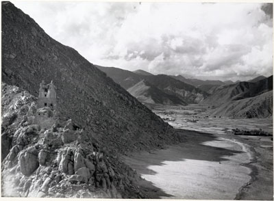
Notes on print/mount - 'Nyang chu Valley' has been written beneath the image in the album in pencil, apparently not by Hugh Richardson [MS 26/08/2006]
Other Information - Album: This image appears alongside 3 others of scenes on the route to Lhasa on page 67 of Hugh Richardson's album 'Lhasa 1936' [MS 26/08/2006]
Manual Catalogues - Caption in Chapman's hand-written list of negatives made whilst on the Mission to Lhasa, 1936-7 [See PRM Manuscripts Collection]: 'Chusul ruined dzong and valley'; PRM Manuscripts Collection: ‘List of Tibetan Prints and Negatives’ - Book 1, From Gangtok to the Natu La August 1936: ‘27/4 - Ruined fort above Chu-shur valley - barley, oats, peas and mustard’ [MS 12/03/2006]
Other Information - Setting: In Lhasa the Holy City [London: Chatto & Windus, 1938; reprint, London: Readers Union Ltd., 1940, p.65] Chapman wrote of the Chushul valley: "The banks of the river are too high here to allow of any irrigation, and only at the foot of streams coming from the hills are there villages, monasteries, and cultivation. The valley is dead flat and the mountains rise straight out of the plain as from the sea. The river has reduced miles of land to sandy wastes with occasional islands of willow scrub. The sand-storms must be terrible in winter" [MS 24/6/2005]
Other Information - Dates: A date of 22nd or 23rd August has been attributed to this photograph because it was on these dates that, according to the official Mission Diary compiled by Chapman in his role as Mission secretary, the Mission caravan passed into the valley [MS 25/2/2005]
Other Information - Agriculture: Small irrigation channels are visible when the image is magnified, from which water would be taken from the river to the fields. The Chushul valley was, and still is, the main grain producing area of central Tibet. [TS 13/01/2005]
Other Information - Related Images: Images prefixed with 'C.11' comprise a group of negatives containing images of Chusul, including a panorama [MS 01/04/2006]
For Citation use:
The Tibet Album.
"Nyang Chu Valley near Chushul"
05 Dec. 2006. The British Museum.
<http://tibet.prm.ox.ac.uk/photo_BMR.86.1.67.4.html>.
For more information about photographic usage or to order prints, please visit the The British Museum.
© The British Museum


